04 May 2016

Discovering the difference between
Puffin Island and Puffin stamps

Puffin Island seen from the shoreline at Penmon (Photograph: Patrick Comerford, 2016)

Patrick Comerford

Like most schoolboys of my age, I spent some time – perhaps as much as six months – as an enthusiastic stamp collector.

I remember the glee I had in finding Puffin stamps that could not fit into the categories provided. Which country were they from? Were they real postage stamps?

And, like schoolboys in the early 1960s, I gave up stamp collecting after that initial flush of enthusiasm. As a comedian once said, I realised philately was getting me nowhere.

But in the back of my mind, I always thought that Puffin Island and Lundy Island where the stamps came from were one and the same place.

Now, however, I know otherwise.

During my weekend in north Wales, I went for beach walks in Beaumaris, at Port Meirion and in Penmon on the most easterly tip of the island of Anglesey. But the weather prevented two of us from booking a planned boat trip from Beaumaris Pier around Puffin Island. We thought it might have been a little like our visit to Ireland’s Eye two years ago, or similar to a boat trip around Dalkey Island a few weeks later.

A walk on the beach beside Beaumaris Pier earlier this week (Photograph: Patrick Comerford, 2o16)

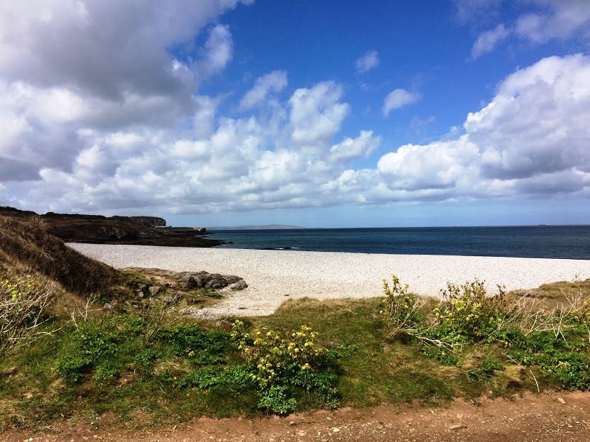
We put aside any plans for a boat trip, and instead decided to visit the ancient Celtic monastic site at Penmon on Monday afternoon. And there, as we walked along the beach, we found ourselves, by surprise, looking out onto Puffin Island, half a mile off the coast.

This island is called Puffin Island in English, but its name in Welsh name is Ynys Seiriol (Saint Seiriol’s Island). Local folklore says Saint Seiriol established a cell or hermitage and a community on here at the same time as he founded his monastery at Penmon.

Tradition also says Saint Seiriol and perhaps is buried on Puffin Island, along with Maelgwn Gwynedd, the King of Gwynedd who helped the saint establish his monastery in the first half of the sixth century.

The Vikings knew the island as Priestholm. The monastic community there managed to survive the Viking attacks on Penmon in the tenth century, and the island has a number of ruins of mediaeval monastic buildings, including the tower of a 12th century church.

The island is mentioned by Gerald of Wales in his Journey through Wales in 1188. He notes that it was an ecclesiastical settlement at the time, “inhabited by hermits, living by manual labour and serving God.” He also says that, according to legend, whenever there was strife within the community a plague of small mice would devour all their food.

Trwyn Du Lighthouse was built in 1835-1838 (Photograph: Patrick Comerford, 2016)

When Lewis Morris made a hydrographic survey of the coast of Wales in 1748, he suggested converting the tower of the ruined church on Puffin Island into a lighthouse, but his proposals were never implemented.

Almost a century later, on 17 August 1831, the Rothesay Castle, a wooden-hulled paddle steamer on a day trip from Liverpool, sank in very heavy seas. More than 140 people were on board, but only 23 of them survived. Afterwards, the Trwyn Du Lighthouse and a lifeboat station were built in efforts to prevent similar tragedies.

Trwyn Du Lighthouse stands at Dinmor Point, at the north entrance to the Menai Strait and marks the passage between Anglesey and Puffin Island.

The lighthouse is 29 metres tall. It was designed by James Walker and built in 1835-1838 at a price of £11,589. This was Walker’s first sea-washed tower, and it became a prototype for his more ambitious towers.

The lighthouse has a stepped base designed to discourage the huge upsurge of waves that had afflicted earlier lighthouses on the site and reduce the force of the water at the bottom of the tower.

Austere vertical walls, instead of the usual graceful lines of other rock towers, are probably an economy measure. The tower has a crenelated stone parapet, in preference to iron railings on the gallery, and narrows in diameter above the half-way point. Walker used these features in his other lighthouse designs. The tower is distinguished by its original three black bands painted on a white background.

The tower has been without any resident staff since 1922, the lamp was converted to solar power in 1996 and the lighthouse was modernised extensively at the same time.

Today, the lighthouse has a 15,000 candela light that can be seen 22 km away. A 178 kg fog bell that sounds once every 30 seconds, and the lighthouse is checked from Holyhead Control Centre.

A lifeboat station built nearby in 1832. Over the years, the Penmon lifeboats saved at least 143 lives until the station closed in 1915, giving way to a lifeboat at Beaumaris.

Puffin Island once had large numbers of puffins and guillemots. However, a more recent plague of brown rats made their way onto the island in 1890s, decimating the populations of nesting birds. At this time the puffin population was already declining because the birds had become a delicacy, but the rats further reduced their numbers to just 20 pairs a few years ago.

The Countryside Council for Wales began a programme in 1998 to rid the island of the rats, in the hope of encouraging the birds to return. Puffin Island is also home to cormorants, shags and fulmar, as well as a colony of grey seals. The tour operators from Beaumaris also offer possible sightings of dolphins and porpoise.

The beach at Penmon has received many awards (Photograph: Patrick Comerford, 2016)

The beach at Penmon has received many awards and since 2003 has displayed the yellow and blue flag. The area is popular with local people and visitors alike because of its monastic sites, its tranquillity, the bracing air and the fine views of Snowdonia to the south across the Menai Strait. The Anglesey Coastal Path follows these shores, but the sound between Puffin Island and Penmon Point (or Trwyn Du) remains treacherous.

The Anglesey Coastal Path follows the shores at Penmon (Photograph: Patrick Comerford, 2016)

Meanwhile, once I had left Puffin Island behind earlier this week, I realised those Puffin stamps never came from Puffin Island. Instead, as I know now, they came from Lundy Island (Ynys Wair), the largest island in the Bristol Channel, 19 km off the coast of Devon, and about a third of the distance across the channel from Devon to South Wales.

Because of a decline in the population of Lundy Island in the 1920s, the Post Office decided to end its presence on Lundy in 1927.

For the next two years, Martin Coles Harman, who had bought the island and proclaimed himself king, handled the mail to and from the island without charge. In 1929, he decided to offset the expense by issuing two postage stamps – a ½ Puffin in pink and 1 Puffin in blue, with one puffin equal to one English penny.

The printing of Puffin stamps continues and the cost of the Lundy Island stamps covers the cost of postage of letters and postcards from the island to the Bideford Post Office on the mainland. Many are now highly sought-after by collectors, and the market value of the early issues has risen substantially over the years.

Perhaps I should have held on to those Puffin stamps all those years ago. Then I would have known the difference between Lundy Island and Puffin Island before I visited Penmon last Monday.

A visit to Penmon at the end of Angelsey,
one of the earliest Christian sites in Wales

Penmon Priory … the former cloisters are enclosed by the former refectory (left), the former prior’s house (centre) and Saint Seiriol’s Priory Church (right) (Photograph: Patrick Comerford, 2016)

Patrick Comerford

I went to the ends of Anglesey earlier this week to visit one of the earliest Christian sites in Wales. On the recommendation of the Rector of Beaumaris, the Revd Neil Fairlamb two of us travelled out east to the edge of the island.

It was a short drive of only 5 km (3 miles) east from Beaumaris to Penmon, whose name in Welsh means the end of Anglesey (pen, promontory; and Môn, Anglesey).

We were not quite at the end of the world, but we were at the eastern tip of Anglesey, looking out towards Snowdonia on the other side of the Menai Straits and out to the Irish Sea.

Looking out towards Snowdonia from the grounds of Penmon Priory (Photograph: Patrick Comerford, 2016)

On the short journey, the landscape was evidence of the way Penmon limestone was used to build Birmingham Town Hall and in rebuilding Liverpool and Manchester after World War II. The stone was also used in building the Menai Suspension Bridge (1826) and the Britannia Bridge (1850).

Saint Seiriol’s Church at Penmon may be part of the oldest remaining Christian building in Wales. According to tradition, a community grew up at Penmon around a monastery (clas) established in the early sixth century by Saint Seiriol on land provided by his brother, Saint Einion, King of Llyn.

Two friends, Saint Seiriol and Saint Cybi, founded monasteries at opposite ends of Anglesey. Saint Cybi’s monastery was on the north-west tip of the Anglesey at the heart of what is now Holyhead, whose Welsh name Caergybi recalls the saint. Saint Seiriol set up his monastery at Penmon, at the eastern tip of the island.

According to folklore, these two saints met weekly near Llanerchymedd, near the centre of the island. Saint Cybi would walk from Holyhead, facing the rising sun in the morning and the setting sun in the evening. Saint Seiriol, travelling in the opposite direction, had the sun to his back during his journey. And so they were known as Cybi the Dark, because he was tanned on his journey, and Seiriol the Fair.

Although Saint Seiriol later moved offshore to a hermitage on Puffin Island, Saint Seiriol’s Monastery prospered and grew in size. By the 10th century, the monastery had a wooden church building, and two crosses that probably stood at the entrance to the monastery complex.

After Penmon was destroyed during Viking raids in 971, the church was rebuilt in stone, and Penmon survived the initial Norman invasion of Gwynedd between 1081 and 1100, when it was defended by Prince Gruffudd ap Cynan of Gwynedd.

The chancel of the Priory Church (Photograph: Patrick Comerford, 2016)

During the 12th century, the Priory Church was rebuilt in stone under Gruffudd ap Cynan and Owain Gwynedd, from 1120 to 1123, and the oldest parts of the Priory Church today date from 1140. This is the most complete building of its age in north-west Wales.

In the 13th century, under Llywelyn ap Iorwerth, the monasteries in Wales were reorganised under the Augustinian rule. Penmon became an Augustinian priory, the church was enlarged and new conventual buildings were built.

Penmon Priory expanded and survived the English conquest of Wales during the reign of King Edward I. There are records for the election of Priors back to 1306, when Iowerth the Prior is named.

The three-storey southern range of buildings once included the refectory with a dormitory above (Photograph: Patrick Comerford, 2016)

The dining hall was on the first floor, with a cellar below and dormitory above. In the 16th century, a kitchen and a warming house were added at the east of the building. The eastern range of buildings has gone, but the southern one, containing the refectory with a dormitory above, still stands.

Llywelyn Fawr and his successors made the church wealthy with generous grants of land. However, in the period immediately before the Reformation, Penmon Priory was already in decline, and by 1536 the community included only the Prior and two other members.

With the Dissolution of the Monasteries, the priory was dissolved in 1538, and the buildings and land became the property of the Bulkeley family of Beaumaris, a prominent local family who used most of the land for a deer park and built the dovecote near the church.

Saint Seiriol’s Church survived the Reformation and remains in use as the parish church of Penmon (Photograph: Patrick Comerford, 2016)

However, the church survived the Reformation and Saint Seiriol’s Church, which was the centrepiece of the monastery, remained in use. Much of the church was rebuilt in 1855, and the chancel now serves as the parish church, while the transepts and nave remain part of the church complex.

The church has a typical cruciform arrangement. The nave, which is the oldest part, was completed ca 1140. The transepts and the tower were built in 1160-1170, and the chancel was added in 1220-1240 during the rule of Llywelyn ap Iorwerth (Llywelyn the Great), who convinced the monasteries in North Wales to reorganise under the Augustinian Order.

A refectory was built around this time, with a large dining hall, cellars and a dormitory. This three-storey building is now roofless.

The building between the refectory and the south transept was the prior’s house, probably built in the 16th century. It is now a private house. The area in the middle was the cloister, and there may at one time have been another building on the eastern side, enclosing the cloister.

The Romanesque arches linking the crossing with the chancel and the south transept (Photograph: Patrick Comerford, 2016)

Inside the church, the nave is quite plain, with small, high windows. The squat, conical tower is a well-known landmark. At ground level, the crossing has richly carved pillars and Romanesque arches. The decorative work suggests skills that may have come from Ireland.

The south transept is embellished with a blind arcade of chevron-decorated Romanesque arches. A series of carved stones found during restoration have been reset in the south transept, where the small window contains fragments of mediaeval glass.

The church shelters two tenth century High Crosses that once stood at the entrance to the mediaeval monastery, as well as a decorated font that also survived the Viking raids in the late tenth century.

The larger cross in the nave (Photograph: Patrick Comerford, 2016)

The larger cross in the nave is badly weathered having stood outside in the deer park until 1977. It is almost complete except for about 30 cm between the top of the shaft and the head. The cross has inter-lacing decorative patterns and a pictorial scene showing the temptations of Saint Anthony, as well as a probable hunting scene.

The smaller cross in the south transept (Photograph: Patrick Comerford, 2016)

The smaller cross, in the south transept, is much less weathered. One arm of the cross was cut off when it was used as a lintel for the refectory windows. The cross is mainly decorated with knot-work along with two animal heads on the sides, and has a modern stone base.

The baptismal font may have been the base of a third cross (Photograph: Patrick Comerford, 2016)

The baptismal font at the end of the nave is decorated with three panels of very similar fret decoration, and originally may have been the base of another, third High Cross. It too has a modern base.

All three pieces belong to a school of sculpture that absorbed stylistic traits from northern English, Viking and Irish art. They date from the late tenth or early 11th centuries, perhaps from the relatively peaceful reign of Gruffydd ap Llywelyn, and the sculptors who created them may have had close connections with Cheshire.

Saint Seiriol’s Well may include parts of the oldest remaining Christian building in Wales (Photograph: Patrick Comerford, 2016)

Below the church, Saint Seiriol’s Well was believed to have healing powers. The well is at the end of a path past a fish pond built by the monks. The well is enclosed within a small building, most of which is brick from 18th century rebuilding work, although the flooring and lower parts of the wall are probably older.

It is said that the lower stone walls near the well were part of Saint Seiriol’s church in the sixth century. If so, this would make it the oldest remaining Christian building in Wales.

The dovecote at Penmon was built by Sir Richard Bulkeley of Beaumaris in 1600 (Photograph: Patrick Comerford, 2016)

Sir Richard Bulkeley of Beaumaris, who owned the monastery lands after the dissolution, built the dovecote near the church ca 1600. The dovecote was built to house pigeons, who were valued for their eggs and meat. The square building has a large domed roof with a cupola that allowed the birds to fly in and out. Inside, there were 1,000 nesting boxes. A pillar in the centre of the dovecote supported a revolving ladder that gave access to the nesting boxes.

Penmon was one of the settings in The Fever (2004), a film starring Vanessa Redgrave and Angelina Jolie. Filming took place at the Priory and the dovecote was used to depict a deserted church. Penmon Priory has also been used for the BBC programme Songs of Praise, and in 1960 for filming the television show Danger Man starring Patrick McGoohan.

Penmon Priory is now part of the Rectorial benefice of Beaumaris in the Diocese of Bangor, with the Revd Neil Fairlamb as Rector. Penmon Priory remains the finest and most complete example of a church of its period in Gwynedd, and is worth going to the ends of Anglesey to see and explore.

The cupola allowed the birds to fly in and out of the dovecote (Photograph: Patrick Comerford, 2016)